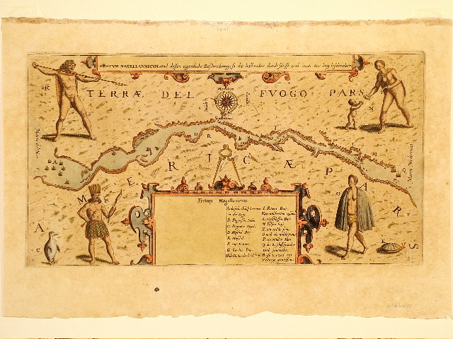
Theodore De Bry. Frankfurt, 1601. 165 x 305 mm. [6-1/2 x 12 in.]
The Strait of Magellan is detailed, with north at the bottom, showing ships sailing the passageway between Terrae del Fuogo Pars and Americae Pars. Depicted are various natives and indigenous creatures, including a penguin and a turtle, engraved on copperplate. $975.
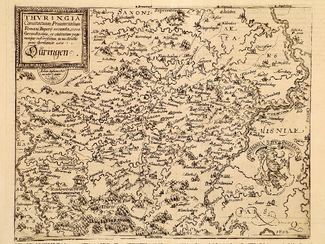
Matthias Quad von Kinckelbach. Cologne, 1603. 215 x 270 [8-3/8 x 10-5/8 in.]
A veritable "Tannhauser" map, showing Wartburg, with a tiny engraved castle on a hill overlooking a valley. Nearby is "Reinhartsbrun, ubi antiquorum Lantgraviorum sepultura", and above it a singing festival hall, beautifully engraved on copper. The date 1603 is engraved at the lower right. $475.
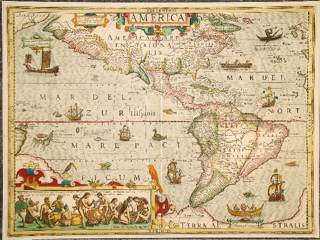
Joducus Hondius. Amsterdam, 1606/1628. 375 x 500 mm. [14-3/4 x 19-3/4 in.]
Regarded by collectors as one of the most beautiful of the 17th century maps of the Western Hemisphere, this map was engraved on copperplate by Hondius himself for his own first edition of Mercator’s atlas. The enormous bulge on the southwest coast of South America has been corrected, and an allegorical vignette at the bottom depicts Brasilian natives preparing a brew, and females chewing up roots and spitting it out into a common caldron. This copy is from a French edition. California appears as a huge peninsula, although starting around 1624 it was depicted as an island, a fallacy which most cartographers subscribed to by 1650 and continued into the mid-eighteenth century. SOLD
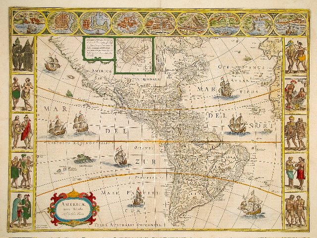
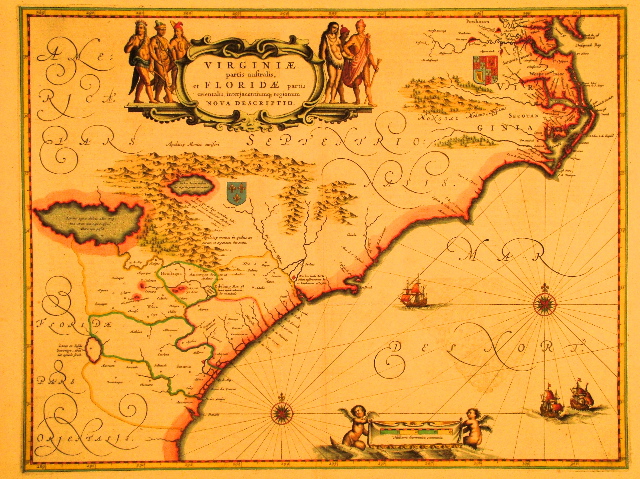
Willem Blaeu. Amsterdam, 1617/1645. 410 x 550 mm. [16-1/8 x 21-5/8 in.]
Originally published separately, this copperplate engraving from a Latin edition of Theatrum Orbis Terrarum represents state five of this important map by Willem Janszoon, who later changed his name to Blaeu to avoid being confused with a competitor named Jan Jansz. Ten vignettes in the side borders present American natives in costume, including those of Virginia, Florida, Mexico, Chile, Brazil and Peru, among others. Nine city views along the top border show Havana, St. Domingo, Cartagena, Mexico City, Cusco, Rio de Janeiro and others. These representations are derived from De Bry and others. Tiny gold dots highlight areas where gold was to be found, particularly along the coasts of Mexico and Brazil. $5,600.
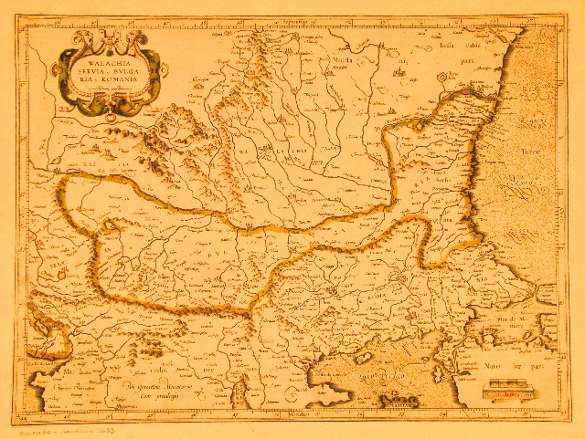
Gerhard Mercator / Joducus Hondius. Amsterdam, 1633. 350 x 470 mm. [13-3/4 x 18-1/2 in.]
Included at far right is the ancient Christian city of Constantinopolis, which fell to the Muslims in 1453, later to become Istanbul. Other placenames in Latin include Rascia, Macedonie, Moldauie, Bessarabia, and Natoliae on this copperplate engraved map, which is bordered by an engraved latitude/longitude ruler. $200.
Willem Blaeu / Joannes Janssonius. Amsterdam, circa 1639. 390 x 505 mm. [15-1/4 x 19-7/8 in.]
Janssonius’ version of the Blaeu presentation of the southern Atlantic coast is virtually identical to Blaeu’s 1638 edition with only minor corrections. $1,500.
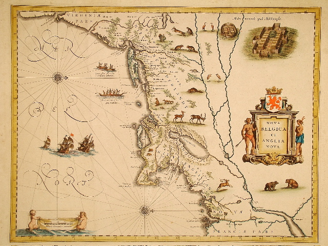
Willem Blaeu. Amsterdam, 1647. 390 x 505 mm. [15-3/8 x 19-7/8 in.]
North is to the right on this copperplate engraving, with charming depictions of natives’ villages and their canoes, sailing ships, and wildlife. At the top is Nieu Nederlandt, which includes Nieu Amsterdam [New York] and Manatthans [Manhattan]; the Montauk area of eastern Long Island is named Matouwac. Below is Nieu Engeland, including C. Cod, Nieu Pleimouth and Briston [Boston]. $3,800.
Matthaus Merian. Frankfurt, 1648. 280 x 360 mm. [10-7/8 x 14-1/8 in.]
Numerous Latin placenames cover the continents on this copperplate engraving. SOLD
Jansen Janssonius. Amsterdam, circa 1650. 395 x 490 mm. [15-1/2 x 19-1/4 in.]
Beautifully colored mid-17th century map of France. SOLD
Jansen Janssonius. Amsterdam, circa 1650. 380 x 495 mm. [15 x 19-1/2 in.]
Beautifully colored mid-17th century map of south Atlantic coastal region of France. SOLD
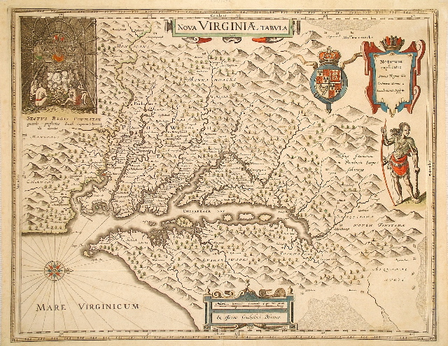
Willem Blaeu. Amsterdam, 1663/1667. 375 x 480 mm. [14-7/8 x 18-7/8 in.]
Classic representation of "Chesapeack Bay", and the famous depiction of a meeting with Chief Powhatan in the meeting house, subtitled "Status Regis Powhatan quando prefectus Smith Captiuus illi daretur." Placenames such as "Appamatuck" and hundreds of other Indian names dot the copperplate engraved map, along with Latinized names and English names such as "Cape Henry" and "Cape Charles." Ex "Le Grand Atlas." Most important derivative of John Smith's map of Virginia originally published in 1612. "Ex officina Guiljelmi Blaeuw," 1630, State 2. $1,800.
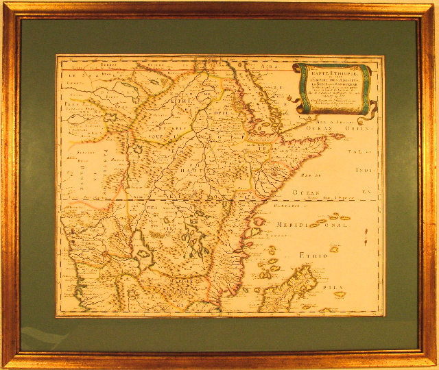
Nicolas Sanson d'Abbeville. Paris, 1655. 400 x 500 mm. [15-3/4 x 19-3/4 in.]
Central and eastern Africa, including the Red Sea in the north and the island of Madagascar in the south, are shown in great detail on this copperplate engraving. The Nile River and its many branches ending in large lakes occupy much of the center. Numerous hills and mountains are beautifully engraved throughout the map. Handsomely framed. $750.
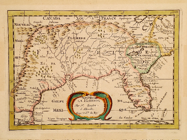
Nicolas Sanson d'Abbeville / Joannes Ribbius. Utrecht, 1657/1682. 180 x 255 mm. [7 x 10 in.]
Sanson’s copperplate engraving La Floride was the first map in an atlas to correctly use the name L. Erie, but it drew strongly on the Ortelius/Chiaves 1584 map by the same title. This specimen is derived from Curieuse Aenmerckingen der bysonderste Oost en West Indische published by Joannes Ribbius and Simon de Vries. In the area of present day Georgia is Lac Grande, possibly a reference to Okefenokee Swamp. $1,900.
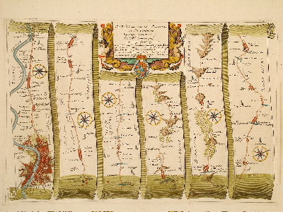
John Ogilby. London, 1675. 295 x 440 mm. [11-5/8 x 17-3/8 in.]
Produced by the inventor of the road map, this copperplate engraved ‘strip map’ is extracted from John Ogilby’s 1675 publication Britannia, which offered a complete road atlas of England. The roads are engraved on an engraved scrolling ribbon. A finely detailed map of London appears, along with charming references at every stop on the road. Since placing the road on strips discounts the possibility of having one compass orientation, a small compass appears on each strip to indicate the direction of north. The very large scale is one inch to a mile. The size of the volume proved to be too large and cumbersome for most to take on their travels, but the impact on cartography was great, and strip maps are still in use today, like the ones produced by the American Automobile Association to chart trips for its members. SOLD
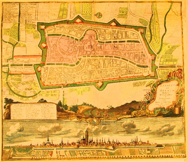
Matthaeus Seutter. Augsberg, circa 1675. 490 x 565 mm. [19-1/4 x 22-1/4 in.]
Beautiful copperplate engraved map of Utrecht with dual lists in German and Latin of 26 key-numbered sites about the city; with very finely engraved view of the city surrounded by a moat and its outlying fields of cultivation. Clouds drift past church steeples so numerous one can barely count them. $500.
Allain Mallet. Paris, 1683. 150 x 110 mm. [5-7/8 x 4-1/4 in.] + page header.
Charming view of St. Augustine, Florida. Alain Menesson Mallet (1603-1706), a French engineer who did service in the Portuguese Army, also served under Louis XIV. In 1683 he published in Paris Description de L’Univers, a five volume work comprised of maps, plans and views. A later German edition was published in 1686. SOLD
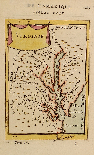
Allain Mallet. Paris, 1683. 150 x 105 mm. [5-7/8 x 4-1/8 in.] + page header.
Small engraved map of the Chesapeake Bay area with nomenclature including Mariland, Powhatan, Jamestowne, Baye de Chesapeach, Patouuomeck R.; and Apalatey ou Apalatay M. Allain Manesson Mallet (1603 - 1706), a French engineer who did service in the Portuguese Army, also served under Louis XIV. In 1683 he published in Paris Description de l’Univers, a five volume work comprised of maps, plans and views. A later German edition was published in 1686. SOLD
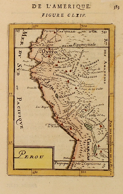
Allain Mallet. Paris, 1683. 145 x 100 mm. [5-3/4 x 4 in.] + page header.
Details of mountains and native villages are given on this miniature map of Peru. Allain Manesson Mallet (1603 - 1706), a French engineer who did service in the Portuguese Army, also served under Louis XIV. In 1683 he published in Paris "Description de l’Univers", a five volume work comprised of maps, plans and views. A later German edition was published in 1686. SOLD
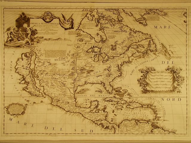
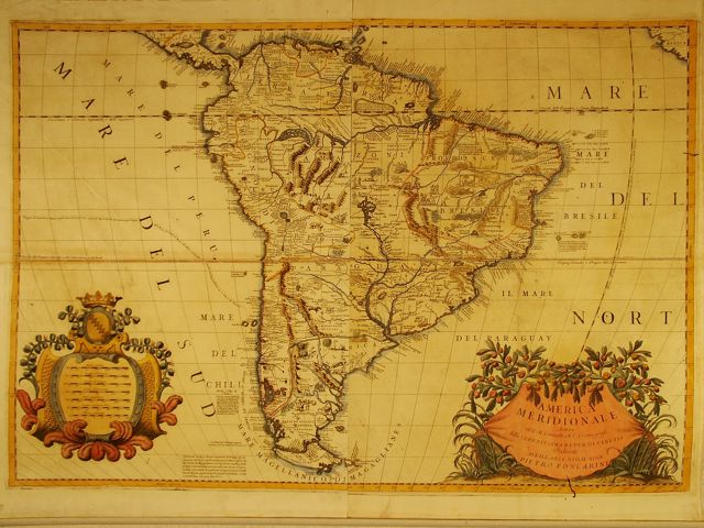
Vicenzo Maria Coronelli. Venice, 1688/1696. 615 x 890 mm. [24-1/4 x 35 in.]
This magnificent copperplate engraved map of North America features greater cartographic detail than Coronelli’s map of 1689, and is substantially larger. Although published in 1696, this depiction of North America is presented Colle Nuoue Scoperte fin all’ Anno 1688 [With New Discoveries made in the Year 1688]. Coronelli issued several versions of this map, including the entire continent on one sheet in 1689; globe gores for reference; and it appeared on fine globes for which Coronelli was well known. It was on this series that the first form of Natchez nomenclature makes a regular appearance on a printed map [as Natche representing the Indian tribe]. California is depicted as a huge island, separated from the mainland by El Mar Vermeio o’ Cortese, detto dalli Francesi Mer Rouge. This map is two map sheets joined, most likely by the publisher. Numerous textual notations relate the history of discoveries on the continent, including those of LaSalle in 1679 and 1682. Coronelli had gained favor with Louis XIV after presenting the King with a fabulous set of huge globes. Tiny vignettes include scenes of native villages and of natives building fires, cooking, navigating primitive craft in the Gulf of Mexico, and being eaten by alligator. The mouth of the Mississippi is located too far west, just a few miles from the mouth of the Rio Grande. Some historians believe this was due to LaSalle’s efforts to convince the King of France that the Mississippi River would bring France’s claims closer to the reputed gold and silver mines of New Spain, making a French empire in this part of America far more important. $24,000.
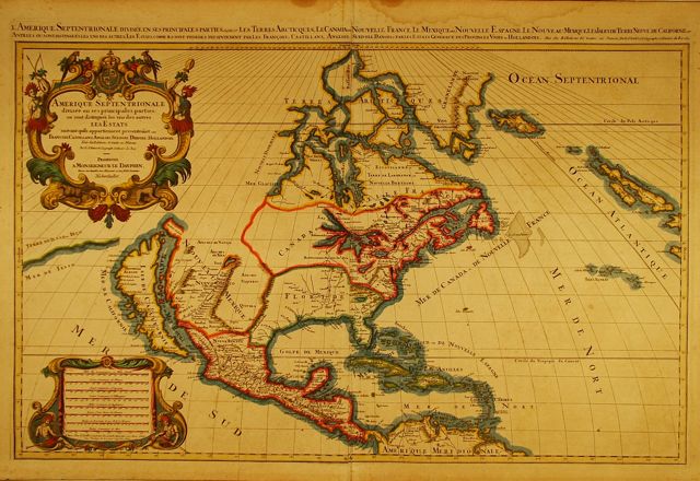
Nicolas Sanson d'Abbeville / Alexis-Hubert Jaillot. Paris, 1692. 575 x 875 mm. [22-5/8 x 34-1/2 in.]
Prepared by Sanson, and first issued in 1674 by Jaillot. The river systems of the southeast are confused, for where the River Spiritu Sanctu [an early name for the Mississippi River] appears, there are virtually no Indian tribes placed. Instead, the tribes that are known to have been along the Mississippi are placed along the Chucagua R. One of these tribes, Quigualtanqui, is possibly the earliest form of nomenclature for the Natchez Indians. The date 1692 appears both at the end of the title line and in the Jaillot imprint in the lower left cartouche. SOLD
Alexis-Hubert Jaillot. Amsterdam, 1694. 610 x 465 mm. [24 x 18-1/4 in.] + title.
South America, extracted from a French edition of a Jaillot atlas, is situated majestically between two large cartouches, ornately engraved on copperplate and fully hand colored, the lower left announcing the content and a dedication to royalty: L’Amerique Meridionale Divisee en ses Principales Parties, Presente a Monseigneur Le Duc de Bourgogne Par son Treshumble et tres obeissant Sevyiteur H. Jaillot. The lower right presents Eschelle, an eight line table of the scale of miles for the five primary powers of Western Europe, and three other scales, the last being for the sea; followed by the imprint A Paris 1694. Both cartouches depict scenes of South American costumed natives in poses of daily life accompanied by indigenous palm trees and wildlife. SOLD
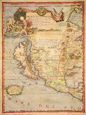
Vicenzo Maria Coronelli. Venice, 1696. 605 x 455 mm. [23-7/8 x 17-7/8 in.]
Although published in 1696, this depiction of the western half of North America is presented Colle Nuoue Scoperte fin all’ Anno 1688 [With New Discoveries made in the Year 1688]. Coronelli issued several versions of this map, including the entire continent on one sheet in 1689; globe gores for reference; and it appeared on fine globes for which Coronelli was well known. It was on this series that the first form of Natchez nomenclature makes a regular appearance on a printed map [as Natche representing the Indian tribe]. California is depicted as a huge island, separated from the mainland by El Mar Vermeio o’ Cortese, detto dalli Francesi Mer Rouge. This sheet is one of two map sheets printed separately of the entire North American continent. It was unusual at the time to find only the western half of the continent represented since most maps tended to present only the eastern half which had been explored far more extensively. Numerous textual notations relate the history of discoveries on the continent, including those of LaSalle’s in 1679 and 1682. Coronelli had gained favor with Louis XIV after presenting the King with a fabulous set of huge globes. Tiny vignettes include scenes of native villages and of natives building fires, cooking, navigating primitive craft in the Gulf of Mexico, and being eaten by alligator. Notice that the mouth of the Mississippi is located too far west. Some historians believe this was due to LaSalle’s efforts to convince the King of France that this waterway would bring France’s claims closer to the reputed gold and silver mines of New Spain, making a French empire in this part of America far more important. SOLD
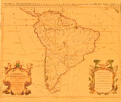
Vicenzo Maria Coronelli. Venice, 1696. 605 x 880 mm. [23-3/4 x 34-5/8 in.]
Copper engraving of South America with two large cartouches at lower left and right. Companion piece to the Coronelli North America map. $4,000.